 www.geodatenkatalog.de (S2F)
Keyword
land use
1939 record(s)
Provided by
Type of resources
Available actions
Topics
Keywords
Contact for the resource
Update frequencies
Service types
-
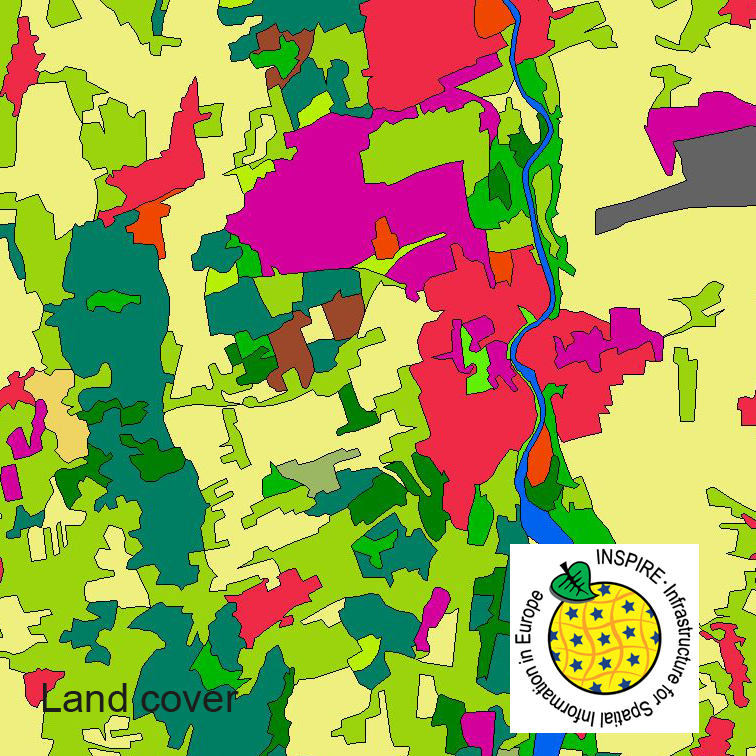
This serie clc5 describes the landscape according to the CORINE Land Cover (CLC) nomenclature. These classes contain mainly information about landcover mixed with some aspects of landuse. CLC5 is based on the more detailed German landcover model (LBM-DE) which uses separate classes for landcover and landuse and attribute-information about percentage of vegetation and sealing. The mimimum unit for an object is 1 ha. For the CLC5 dataset landcover and landuse classes are combined to unique CLC-classes taking into account the percentage of vegetation and sealing, followed by a generalisation process.
-
This dataset clc5 (2012) describes the landscape according to the CORINE Land Cover (CLC) nomenclature. These classes contain mainly information about landcover mixed with some aspects of landuse. CLC5 is based on the more detailed German landcover model from 2012 (LBM-DE2012) which uses separate classes for landcover and landuse and attribute-information about percentage of vegetation and sealing. The mimimum unit for an object is 1 ha. For the CLC5 dataset landcover and landuse classes are combined to unique CLC-classes taking into account the percentage of vegetation and sealing , followed by a generalisation process.
-
This dataset clc5 (2018) describes the landscape according to the CORINE Land Cover (CLC) nomenclature. These classes contain mainly information about landcover mixed with some aspects of landuse. CLC5 is based on the more detailed German landcover model from 2018 (LBM-DE2018) which uses separate classes for landcover and landuse and attribute-information about percentage of vegetation and sealing. The mimimum unit for an object is 1 ha. For the CLC5 dataset landcover and landuse classes are combined to unique CLC-classes taking into account the percentage of vegetation and sealing , followed by a generalisation process.
-
This dataset clc5 (2015) describes the landscape according to the CORINE Land Cover (CLC) nomenclature. These classes contain mainly information about landcover mixed with some aspects of landuse. CLC5 is based on the more detailed German landcover model from 2015 (LBM-DE2015) which uses separate classes for landcover and landuse and attribute-information about percentage of vegetation and sealing. The mimimum unit for an object is 1 ha. For the CLC5 dataset landcover and landuse classes are combined to unique CLC-classes taking into account the percentage of vegetation and sealing , followed by a generalisation process.
-
Data on industrial production facilities from the Continental Shelf Information System.
-
Data on industrial production facilities from the Continental Shelf Information System.
-
Data on industrial production facilities from the Continental Shelf Information System.
-
Der Bebauungsplan setzt als verbindlicher Bauleitplan das Bodennutzungskonzept der Stadt in unmittelbar geltendes Recht um. Der Bebauungsplan gibt vor, welche Bodennutzungen auf den betroffenen Grundflächen zulässig und unzulässig sind.
-
Der Bebauungsplan setzt als verbindlicher Bauleitplan das Bodennutzungskonzept der Stadt in unmittelbar geltendes Recht um. Der Bebauungsplan gibt vor, welche Bodennutzungen auf den betroffenen Grundflächen zulässig und unzulässig sind.
-
Der Vorhaben- und Erschließungsplan setzt als verbindlicher Bauleitplan eine objektbezogene Vorhabensplanung in unmittelbar geltendes Recht um. Für ihn gelten als vorhabenbezogener Bebauungsplan dieselben Regelungen, die auch für den Bebauungsplan maßgeblich sind.